The Long Range Traverse - Day 1
I've been really lax in writing about this amazing trip. About two years ago, I was looking for an interesting backpacking trip to do and I discovered a brief mention of a hike Gros Morne National Park in Newfoundland, Canada called the Long Range Traverse. The description was pretty brief, but I dug into the trip and I became really obsessed with trying it out. A chance run-in with a friend where I asked her if she wanted to go on a "ridiculous backpacking trip to Canada" resulted in a few months of preparation and planning.
After a mandatory park orientation including a backcountry navigation test and a humorously dated video, we spent the remainder of the day getting last minute supplies. Early the next morning, we dropped or rental car off at the end of the trail, where we had a taxi scheduled to drive us the 20 kilometers to the trailhead at Western Brook Pond. From here we had about a 45 minute walk to the end of a freshwater fjord, where we boarded a boat with two other groups of hikers as well as a number of tourists just there for the ride. The boat dropped us off at a small boat dock, where we got our gear ready and began the Long Range Traverse.
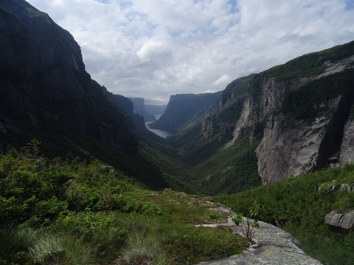
The top of the climb out of Western Brook Pond
Although they recommend solid map-and-compass skills for the trip, the first section up the glacial carved valley of Western Brook Pond is fairly straight-forward due to a well-worn trail and the presence of a few trail markers on trees--the latter betraying the statement that there are no trail markers along the 32-kilometer route. At the top of the 600-meter (~2000-feet) climb, including a near vertical climb next to a waterfall out of the valley, one is greeted by this amazing view! Additionally, the top of the gorge offers the first look at what you’re in for: a endless landscape of mountain meadows, rolling peaks, and shimmering lakes. Although striking, it is a slightly sobering expanse of wilderness --and one can’t help but note that everything sort of looks alike.
From here, navigation was a lot more difficult. Now we were above the treeline, where the harsh, icy winds have scoured the glacier-carved landscape. The trail of previous hikers more or less disappear and its easy to get lost via a navigation puzzle as you try to get around pockets of peatland and open water. Additionally, the meandering footpaths of caribou can entice you away from the proper course--which happened more than once to us. Of course, throughout the trip, there were numerous ecological side trips as I ditched the plan route to look an interesting bog or rock or followed a butterfly for perhaps far too long.
Fog rolling in
Although, we had great weather to see the view from the top of Western Brook Pond, fog was quickly rolling in that afternoon so we made some haste in heading toward camp, especially as we were getting our navigation skills up to speed.

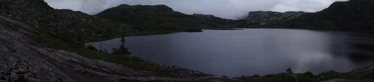
While the whole Long Range Traverse is backcountry hiking and camping, five recommended camping areas with tent platforms and pit toilets are spaced throughout the area. The first night we camped at Little Island Pond. The pond did indeed have an island in the middle of it, which did look like an enticing place to explore via a swim, but the 10C water quickly killed that plan. Overall, this first leg of the trip felt relatively easy, at least easier than I imagined. The next few days would test that...
But we did wake up to this amazing view the next morning.